



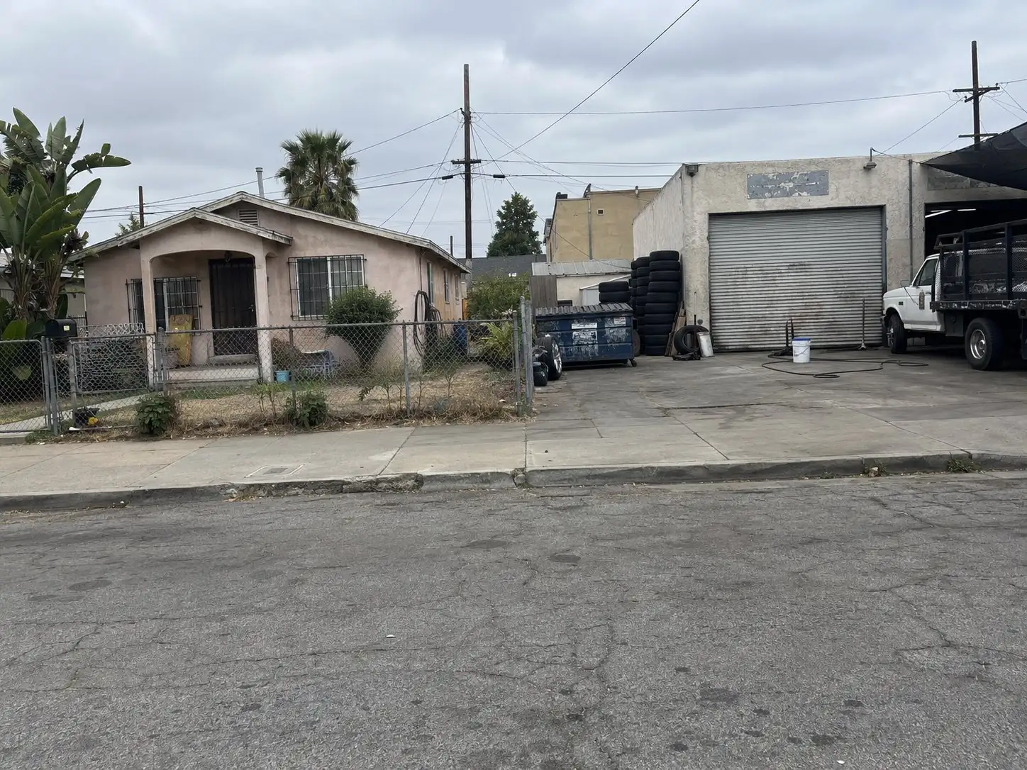
A home can sit on a block where the lot next door is zoned or used differently. In National City’s Westside, the city has said so in its own planning documents for years. That is why the zoning around an address, and not only the address itself, belongs on a buyer’s checklist.
This article covers land use and zoning only. It describes what the City’s published plan and municipal code say, and which public databases exist. It does not describe any resident group, and it does not say whether any address is good or bad. Zarko Maletin is a Realtor and InterNACHI certified home inspector, but environmental site assessments belong to qualified professionals, and the City decides what its code means for a given parcel.
What is the Westside Specific Plan?
It is the City of National City’s land use plan for the Westside neighborhood. The plan describes its area as roughly 100 acres and about 460 parcels, bordered by West Plaza Boulevard to the north, Interstate 5 to the west, West 24th Street and Mile of Cars Way to the south, and Roosevelt Avenue to the east.
The plan states its purpose directly. It was prepared to address future development and redevelopment patterns in the project area and to set out amortization guidelines for incompatible uses. Read the plan itself, not a summary, before you rely on any detail.
Why do homes and industrial uses sit side by side there?
The plan explains the history in its own words. It says city leaders in the 1960s established zoning that allowed light manufacturing, hoping the area would become an industrial district. Large scale industrial redevelopment never happened, in part because the parcels were small and hard to assemble.
As a result, the plan says, a mix of smaller uses became intermixed with residences. It names auto repair, paint and body shops, steel fabrication, plating and warehouses. It also says the area was rezoned to a light manufacturing and residential designation with the 1996 General Plan revisions. For a buyer, the takeaway is practical: the neighbor’s property may have an older use that predates the current rules.
What zoning applies on the Westside today?
The city’s land use code ties the Westside to several named zones. Table 18.20.020 of the National City Municipal Code lists RS-4, a single-family residential zone, as a Westside specific plan zone. It also lists CL, a limited commercial zone, and MCR-1 and MCR-2, mixed commercial and residential zones, with the same Westside reference.
The code describes RS-4 as providing for small lot single-family development within the Westside Specific Plan area, with a minimum lot size of two thousand five hundred square feet. It says the MCR zones provide for commercial or multi-family residential development, or both. The permitted uses in the MCR zones, and the uses allowed in the other Westside zones, are listed in Appendix A of the plan.
The code also sets the rule for conflicts. Lands within an adopted specific plan are governed by that plan’s zoning regulations, and if the plan is silent on a development standard that the code addresses, the code applies. So the zone letters on a parcel are the start, not the finish. You need the plan too.
What does the plan say about new industrial uses?
It says new industrial uses will be prohibited inside the plan boundary. The plan states that adoption will prohibit new industrial uses, including auto body repair, which it calls not compatible with its vision and guiding principles.
That is a statement about what can be newly established. It is not a statement that every older business has gone. Uses that were lawful before the plan can be nonconforming, which means they were legal when established and no longer match the current rules. The next section covers how the code treats those.
What is the amortization ordinance?
Amortization is a legal tool that lets a city set an end date for a nonconforming use. In National City it is written into section 18.11.100 of the municipal code, titled Termination. The City Council may order a nonconforming use to be terminated within a reasonable amount of time, on recommendation of the planning commission, after a public hearing with ten days’ written notice to the user.
The code sets timing rules. If the user has not made a substantial investment in the use, or can recover the investment through a permitted use, the order may require termination in a minimum of one year. If the investment is larger, the order may allow a longer reasonable period. The planning commission must weigh listed factors, including the cost of land and improvements, how long the use has existed, and compatibility with surrounding land use patterns.
One limit matters to a buyer. The code says the section does not apply to any lawful nonconforming residential uses, so it is not aimed at homes. Rules like this get amended, so confirm the current text with the City.
How are nonconforming uses handled in the Westside?
The code gives the Westside its own conversion rules. Under section 18.11.040, a nonconforming use in the Westside Specific Plan may not be converted to another use, except one specifically permitted in its zone or one permitted in the zones listed in Appendix A of the plan. Section 18.11.030 allows certain nonconforming uses that substitute another nonconforming use to expand their footprint within the parcel, but only with a conditional use permit.
A nonconforming neighbor is not frozen, but its options are narrower than elsewhere in the city. If a use next to a house you are considering is important to you, ask the Planning Division what its status is and whether any hearing or order is on file.
Which public tools can a buyer check?
Start with the City of National City Planning Division for zoning and permit history, and then use two state databases for cleanup records. These are tools for looking up records, and a record is not a conclusion about a home.
EnviroStor is run by the California Department of Toxic Substances Control. The department describes it as its data management system for cleanup, permitting, enforcement and investigation efforts at hazardous waste facilities and sites with known contamination, or sites where there may be reason to investigate further.
GeoTracker is run by the State Water Resources Control Board. The board describes it as an internet-accessible database used by the State Board, regional boards and local agencies to track compliance data on discharges of waste to land and releases of hazardous substances from underground storage tanks. It includes leaking underground storage tank cleanups and other cleanup program sites, and it can be searched by address.
Search the subject address and nearby addresses in both, and read what the status field says for each record. A closed case, an open case and a site with no record are different things, and an agency can tell you what a status means. If a record raises a question, a qualified environmental professional is the person to ask, not an agent or an article.
What should a buyer ask before making an offer?
Ask the questions below early and get answers in writing where you can.
What is the zone of the parcel, and is it inside the Westside Specific Plan boundary? What uses are permitted on the neighboring parcels under Appendix A? Is a neighboring business a nonconforming use, and is any amortization hearing or order on file? Do EnviroStor or GeoTracker show a record at or near the address, and what is its status? Does the seller know of anything that belongs on the disclosure forms?
A pre-listing inspection looks at the house, not the soil or the neighbors, so it does not replace those questions. The NHD reports article explains what a natural hazard report does and does not cover. Sellers should read the seller disclosure guide for what belongs on the forms. For another look at buying beside commercial and logistics land, see buying near warehouses in Perris.
The short version
The Westside Specific Plan governs land use in an area where homes and older industrial uses grew up together. The municipal code sets conversion limits on nonconforming uses there and allows the City Council to order some of them to end after a hearing, but not lawful nonconforming homes. Check the parcel’s zone and the plan, ask the Planning Division about neighboring uses, and search EnviroStor and GeoTracker before you write an offer.
If you are weighing a National City purchase and want a starting number first, try the home value tool. It is a starting point, not an appraisal of any specific home.
Common questions
What is the Westside Specific Plan in National City?
It is a land use plan the City of National City prepared for the Westside area. The City's own plan document says it addresses development patterns and sets amortization guidelines for incompatible uses. Under the city's zoning code, land inside an adopted specific plan is governed by that plan's zoning regulations.
Does amortization mean a nearby business will close?
Not automatically. Under section 18.11.100 of the National City Municipal Code, the City Council may order a nonconforming use to end after a planning commission hearing, and the order must allow a reasonable amount of time. Whether any particular business is subject to an order is a question for the city's Planning Division.
Where can a buyer look up a property or a nearby site in state databases?
Two public tools are the Department of Toxic Substances Control's EnviroStor and the State Water Board's GeoTracker. EnviroStor tracks cleanup, permitting and enforcement at hazardous waste facilities and sites with known contamination. GeoTracker tracks sites that affect or could affect water quality, including leaking underground tank cleanups. Neither one is a verdict on a house.
Does the amortization section apply to homes?
The code says the amortization section does not apply to any lawful nonconforming residential uses. It is written for nonconforming uses such as businesses, structures and lots, and it is not aimed at owner-occupied homes.
